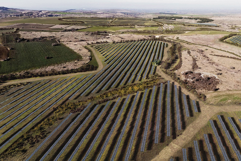
With a highly qualified team of agronomists, foresters and engineers, our company offers innovative solutions for the management, monitoring and protection of agricultural and forest land. Through the advanced use of GIS systems and digital technologies, we support the optimisation of natural resources and promote sustainable development. We provide specialised services for the management and monitoring of environmental, agricultural and forestry resources, with a focus on the disbursement and reporting of EU, national and regional funds. Thanks to an integrated approach and the adoption of the most advanced technologies, we establish ourselves as a national and international reference partner in the field of land management and enhancement.


contacts
GUBBIO
HEAD OFFICE
Via Thomas Alva Edison, 5
06024 Gubbio (PG) Italy
+39075923011
staff@cooprogetti.it
cooprogetti@pec.it
p.iva 00424850543
REGGIO CALABRIA
Via Quarnaro I, 6 – Gallico
89135 Reggio Calabria (RC) Italy
+39075923011
staff.rc@cooprogetti.it
ROMA
Via Volturno, 58
00185 Roma (RM) Italy
c/o consorzio Arcodrea
+39075923011
staff@cooprogetti.it
PERUGIA
Via Giuseppe Lunghi, 21
Ponte San Giovanni
06135 Perugia (PG) Italy
+390755090489
a.ferrelli@cooprogetti.it
PESARO
Via Padre Massimiliano Kolbe, 66
61122 Pesaro (PU) Italy
+390721414021
staff.pu@cooprogetti.it
REGGIO EMILIA
Viale Monte Grappa, 9
42121 Reggio Emilia (RE) Italy
+390522451657
l.baldini@cooprogetti.it
SALERNO
Via Sant’alfonso Maria dè Liguori, 16
84135 Salerno (SA) Italy
+390892855686
staff.sa@cooprogetti.it
AREZZO
Via Galileo Ferraris, 63
52100 Arezzo (AR) Italy
+390575355817
staff.ar@cooprogetti.it
MILANO
Via Carlo Botta, 19
20135 Milano (MI), Italy
+390297164410
staff.mi@cooprogetti.it
TORINO
Via Susa, 11
10050 Chiusa di San Michele (TO), Italy
+3901119118853
staff.to@cooprogetti.it
LECCE
Via Sturzo, 19
73100 Lecce (LE), Italy
+390832318193
staff.le@cooprogetti.it
ARGENTINA – URUGUAY
Avenida Florida 939, Piso 4F, 1005
Capital Federal Buenos Aires
+54114311-4043/45
cooprogetti@cooprogetti.com.ar
PERÙ
Jr. Julio Cesar Tello 215 int. D
Lince
Lima
sucursal.peru@cooprogetti.com
BOLIVIA
Avenida 16 de Julio n. 1479
Edificio San Pablo Piso 15 Zona Central
La Paz
lapaz@cooprogetti.com
CHILE
Vasco de Gama 4703
Las Condes
Santiago Chile
+56 9 90151882
oficina@cooprogetti.cl
PARAGUAY
México 1.039 casi Tte. Farina
Barrio Gral. Díaz;
Asunción
sucursal.paraguay@cooprogetti.com
contacts
GUBBIO
HEAD OFFICE
Via Thomas Alva Edison, 5
06024 Gubbio (PG) Italy
+39075923011
staff@cooprogetti.it
cooprogetti@pec.it
p.iva 00424850543
REGGIO CALABRIA
Via Quarnaro I, 6 – Gallico
89135 Reggio Calabria (RC) Italy
+39075923011
staff.rc@cooprogetti.it
ROMA
Via Volturno, 58
00185 Roma (RM) Italy
c/o consorzio Arcodrea
+39075923011
staff@cooprogetti.it
PERUGIA
Via Giuseppe Lunghi, 21
Ponte San Giovanni
06135 Perugia (PG) Italy
+390755090489
a.ferrelli@cooprogetti.it
PESARO
Via Padre Massimiliano Kolbe, 66
61122 Pesaro (PU) Italy
+390721414021
staff.pu@cooprogetti.it
REGGIO EMILIA
Viale Monte Grappa, 9
42121 Reggio Emilia (RE) Italy
+390522451657
l.baldini@cooprogetti.it
SALERNO
Via Sant’alfonso Maria dè Liguori, 16
84135 Salerno (SA) Italy
+390892855686
staff.sa@cooprogetti.it
AREZZO
Via Galileo Ferraris, 63
52100 Arezzo (AR) Italy
+390575355817
staff.ar@cooprogetti.it
MILANO
Via Carlo Botta, 19
20135 Milano (MI), Italy
+390297164410
staff.mi@cooprogetti.it
TORINO
Via Susa, 11
10050 Chiusa di San Michele (TO), Italy
+3901119118853
staff.to@cooprogetti.it
LECCE
Via Sturzo, 19
73100 Lecce (LE), Italy
+390832318193
staff.le@cooprogetti.it
ARGENTINA – URUGUAY
Avenida Florida 939, Piso 4F, 1005
Capital Federal Buenos Aires
+54114311-4043/45
cooprogetti@cooprogetti.com.ar
BOLIVIA
Avenida 16 de Julio n. 1479
Edificio San Pablo Piso 15 Zona Central
La Paz
+591-(2)-2494393
lapaz@cooprogetti.com
CHILE
El Coihue 3758
Comuna de Vitacura
Santiago Chile
+5622081447
oficina@cooprogetti.cl
PERÙ
Jr. Julio Cesar Tello 215 int. D
Lince
Lima
sucursal.peru@cooprogetti.com
PARAGUAY
México 1.039 casi Tte. Farina
Barrio Gral. Díaz;
Asunción
sucursal.paraguay@cooprogetti.com
certifications
SEDI CERTIFICATE
GUBBIO
REGGIO CALABRIA
UNI EN ISO 9001:2015
UNI EN ISO 14001:2015
UNI EN ISO 45001:2018
ISO/IEC 27001:2013
ISO 37001:2016
ISO 50001:2018
ISO 30415:2021
UNI/PdR 74:2019
UNI/PdR 125:2022
SA 8000:2014
Nulla Osta Sicurezza Industriale (NOSI)
SEDE CERTIFICATA
BUENOS AIRES
UNI EN ISO 9001:2015



Rating di Legalità massimo: 3 stelle
membership


Envision™ Italia Supporter
e Professionisti Certificati Envision™


Cooprogetti Società Cooperativa – P.IVA e C.F. 00424850543 – Albo Soc. Cooperative n. A147262
Società certificata UNI EN ISO 9001:2015 – UNI EN ISO 14001:2015 – UNI EN ISO 45001:2018 per le sedi di Gubbio e Reggio Calabria

